4,600+ Mountain Bald
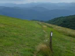
The Appalachian Trail on Max Patch
Max Patch is a 4,629-foot tall mountain bald with an incredible 360-degree mountain vista just 20 miles from Hot Springs. The Appalachian Trail crosses right over the summit running north and south. On a clear day, you can see from Mt. Mitchell on the east to the Great Smoky Mountains on the south. Find out more about visiting Max Patch on our Comprehensive Guide to Max Patch.
Once Home to Cows and Bi-Planes
The bald was created in the 1800’s when it was cleared for grazing of sheep and cattle. In the 1930’s, it was used as an air strip and was said to be the highest in the East. Local folk talk about how Max Patch was often used as a place for air shows with bi-planes and how thousands of people would gather there to take in the spectacle. The bald was privately owned until 1982 when the U.S. Forest Service bought 350 acres to preempt a plan to turn it into a ski resort.
Hiking on Max Patch

Enjoying the View on Max Patch
The vast majority of the people who visit Max Patch hike the 2.4 mile loop trail that begins and ends at the Max Patch parking area. From the parking area you have a choice of going left or right on official trails. Heading left the trail follows an old logging road along the wooded west slope of Max Patch. The trail makes its way around the lush and forested north side of the peak before breaking out into the open air and joining the Appalachian Trail. Follow the wood posts marked with white paint up the summit lawn. From the summit the trail travels toward the east side of the summit and descends into high shrubs. The trail makes its way back around the south side of the peak to the parking area.
Check out the trail map and other trail information on our Comprehensive Guide to Max Patch.
Max Patch has experienced a higher number of visitors in recent years, especially during weekends, and here are some things to know before going. Parking on the road is allowed if the trailhead parking area is full, but do not block through traffic. Please plan ahead as there are no bathrooms or trash cans at Max Patch Trailhead. Practice Leave No Trace Ethics and pack out all your trash. Stay on the blazed trails and do not cut through barriers and fencing used to block off social trails. Camping and fires are not currently allowed.
Learn More at www.maxpatch.org. This website is a collaborative effort by the U.S. Forest Service, Carolina Mountain Club, and Appalachian Trail Conservancy. It provides comprehensive information on the area while also encouraging proper stewardship from visitors. Read a full list of restrictions in effect at Max Patch as of July 1, 2021 here.
It’s Cooler Up Top – Think About a Jacket
In just about any season, Max Patch is 10-15 degrees cooler than Hot Springs or Asheville. During springtime you’ll see an abundance of wildflowers and in summer you may find some wild blueberries and blackberries.
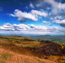
On a Clear Day, You Can See Forever
A word of caution – If the weather becomes stormy with any sign of lightning, descend quickly from the mountain. Remember the 20/20 Lightning Rule: If the time between the lightning flash and the thunder is 20 seconds or less, then the lightning bolt was less than 5 miles from your location. It is time to seek shelter IMMEDIATELY!
Directions from Hot Springs to Max Patch
From downtown Hot Springs, go South on Bridge Street until it turns into Highway 209. Follow Highway 209 (7.3 miles) to Meadow Fork Road (State Road 1175) turning right at an old abandoned stone store. Go 5.3 miles and turn right on State Road 1181. Follow 1181 for 2 miles (turns into gravel). At the top of the mountain, turn right onto State Road 1182 and Max Patch parking lot is 3 miles.
If you’re coming from outside of Hot Springs, check out our 2025 article on Max Patch for other directions.
More Information on Visiting Max Patch
Explore & Hike Max Patch, NC! A Comprehensive Guide to the Scenic Beauty and Adventure